
I decided to schedule a stop-over in Iceland on my way to Germany for Oktoberfest. But having a limited time, I needed to make sure that I planned 3 really great day trips from Reykjavik. Because of my odd flight times, I skipped the paid tours and rented my own car to allow for spontaneous changes. I stayed at the Eyja Guldsmeden hotel in Reykjavik, which was a nice central location for these day trips. So, head out on Highway 1 (generally called the ring road) and enjoy or modify these day trips from Reykjavik.
Day Trips from Reykjavik – The South Coast
I wanted to drive to the farthest planned point before stopping at my first famously picturesque location on the first day trip from Reykjavik. At times, it was terribly difficult not to immediately pull-off when I noticed signage for a turn-off this falls or that tourist site – there were so many! However, I do recommend that anyone taking this route stop when you can or when you see something. I found that the weather can change quickly, and you might not get as good a moment for your pictures on the way back. HINT: The south coast day trip from Reykjavik turned out to be my favorite!
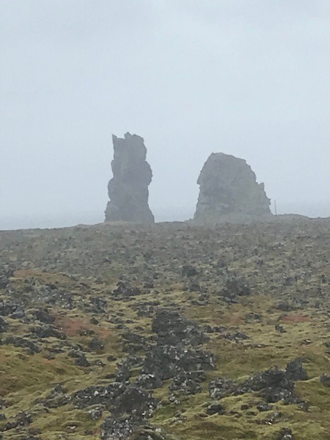
Reynisdrangar Peninsula
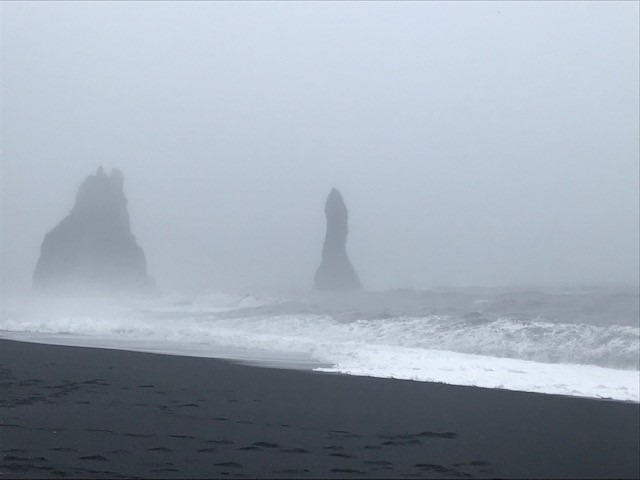
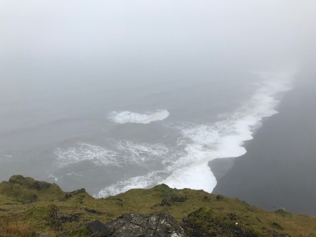
My goodness, what a magical spot. Getting off highway 1 near Vik, I thought I was driving along someone’s private driveway to get to the Black Beach. The misty ocean view of the rock pillar stacks jutting out of the water reminded me of the Oregon (USA) rock formations of Cannon Beach. There are quite a few variations on a local legend of how the rock formations were made. But they all have something to do with trolls being caught out late and frozen before morning. Regardless, they are an exceptional natural sea sculpture.
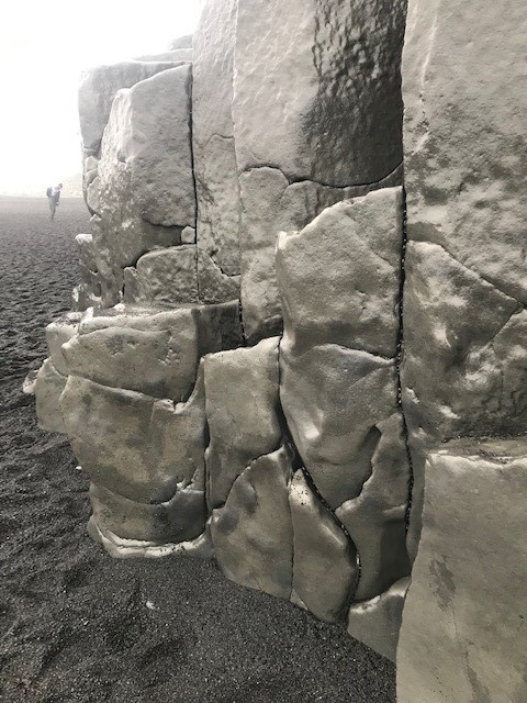
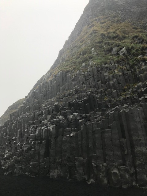
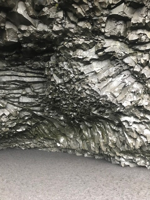
I found the most stunning feature to be the irregular shaped columnar basalt veins formed from volcanic tuff material at the base of the Reynisfjall Mountain and the beach. And a craggy cave known as Hálsanefshellir can be seen just around the bend from the basalt columns. The columns were so touchable, made smooth by the strong ocean winds over time. But I easily pictured the Game of Thrones cast walking up and down the black beach at the oceans’ edge.
Dyrhólaey Viewpoint

Heading back toward Reykjavik on the ring road, there is a turnoff (road 218) for Dyrhólaey. Dyrhólaey literally means “the hill island with the door hole.” Once on the Dyrhólaey road, you can take one of two options and either go up to a higher viewing area or to a lower area. The lower area has limited access during certain times of the year due to weather and/or bird nesting seasons. I was only able to take the higher option that had a magnificent view of The Arch with the Hole. There are two parking areas along this route, one lower and one higher. But take note that the road up is extremely riddled with potholes and should be taken slowly and is almost a one-lane width. I was lucky to be there during off-season and there were few cars when I drove up to the top parking lot.
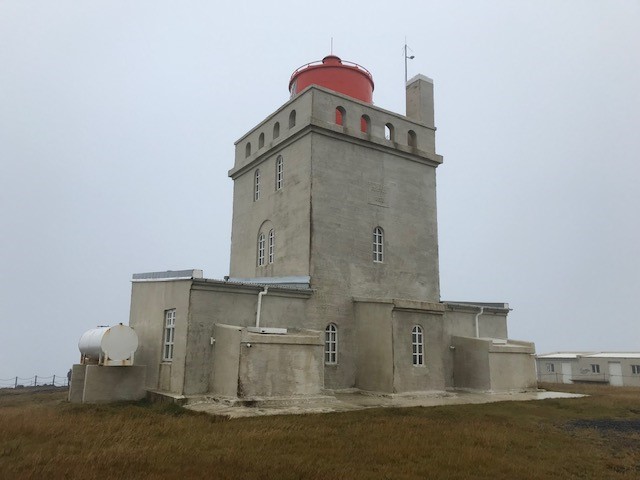
At the top, there is an old lighthouse that was built in 1927 and the area gives you an incredible 180-degree view below. On one side, you can view the beach far below and on the other is a great view of The Arch. It was such a rainy day that The Arch was veiled in a cloudy mist and hard to make out. However, it was still well worth seeing and hiking the area.
Sólheimajökull Glacier
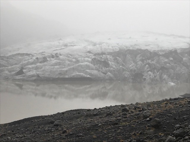
The Sólheimajökull glacier, which is the 4th largest in Iceland and part of the Mýrdalsjökull glacier. It was a bit of a hike from the parking lot to visit this one. But, it was peaceful and not that many people were there the day I went. If you have more time, I could take one of the Sólheimajökull Glacier 3-hour guided tours through TripAdvisor. That way you would be sure to take the best approach to the glacier and not miss its chilling crevasses and sinkholes and the still active Katla Volcano laying beneath the Mýrdalsjökull glacier.
Seljalandsfoss

As you keep traveling the ring road back toward Reykjavik, there is a turnoff for the Seljalandsfoss Waterfall. I have no idea what happened to my photos of this waterfall (so upset!), but it is a wonderful sight and a well-known Iceland waterfall. It was rainy and my photos would not have done it justice in the gloomy weather anyway. But it still would have been nice to show it. There was another waterfall called Gljúfrafoss nearby and hidden away behind Seljalandsfoss in a gorge. But it started raining too much and I didn’t want to slip on the rocks. If you go on a clear day, look for this one because I heard from the locals that you won’t be disappointed.
Skógafoss
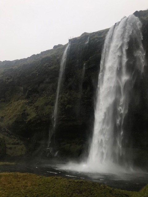
Back on the ring road and about 19 miles further, is the turn-off to the Skógafoss Waterfall (which I saw from the other direction when I first headed toward Vik). This was one of my favorite waterfalls because you can get so close to it. According to a local legend dating back to 900 AD, a treasure chest containing gold and other items was hidden behind the waterfall. A gold ring (said to be torn from the side of the chest when trying to retrieve it) is now displayed in the Skógar Museum.
Day Trips from Reykjavik – The Golden Circle
Although most people taking day trips from Reykjavik would have heard of the Golden Circle as the most well-known attraction area, I found it to have less to offer than day trips from Reykjavik to the south coast. One thing to note ahead of time – when driving the circle, it will not take a day to see everything. So, plan to stay longer at the highlighted spots.
Thingvellir National Park and Falls
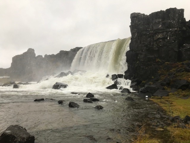
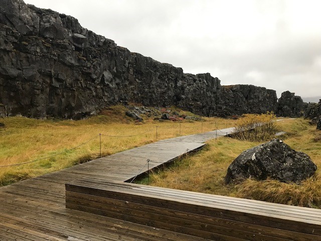
This is one of my favorite places because there was almost no one there when I saw these beautiful falls. From the parking lot you can see the falls but must walk a short distance and up some stairs before getting quite close. The area has been recently developed nicely, with wood planking walkways for a peaceful meandering walk/hike. The waterfall was actually man-made to sustain the early settlement of people when the thirty chiefs of the island starting meeting (sort of an early parliament). In fact, the name Thingvellir means “the fields of parliament.”
It is in the Thingvellir National Park (and the only place in the world), that the rift between the North American tectonic plate and the Eurasian plate is above sea-level. The walkway takes you alongside both plates, ending at the falls. This Mid-Atlantic ridge is drifting apart at about 2 cm per year.
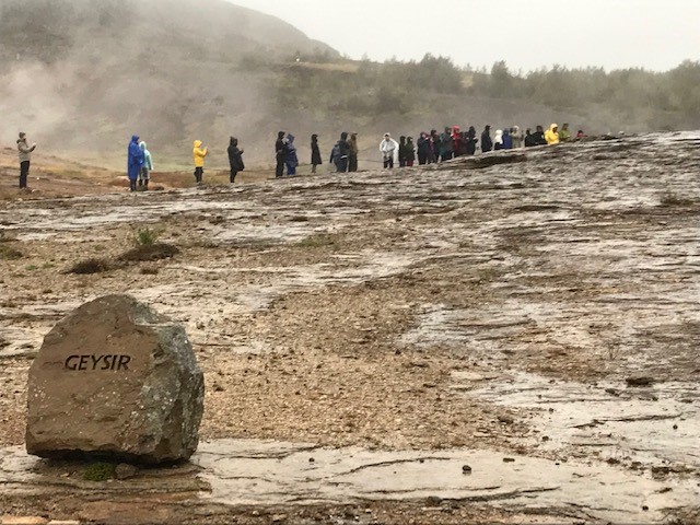
Geysir Geothermal Area
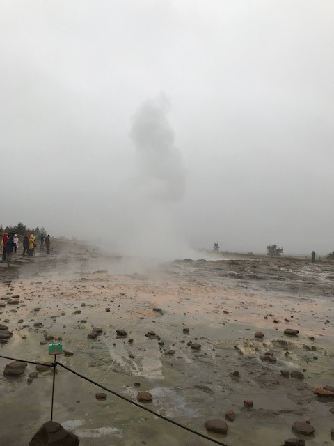
Strokkur Geyser 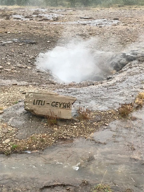
Little Geysir
Continuing on the Golden Circle, the Geysir geothermal area is a high temperature geothermal area with a base temperature of around 250 degrees C. Geysir did not erupt while I was there, and many people had been waiting for a long time before I arrived to try to catch it spout off. It is irregular, but when it does erupt, it has been known to reach 70-80m in height. Compare that to Old Faithfull in the USA, that spouts off every 30-100 minutes and up to 25-55m in height. However, it was nice to see the Strokkur geyser goes off – at regular intervals about every 8-10 minutes.
Gullfoss
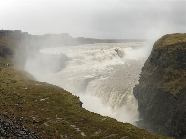
At the farthest point on the Golden Circle lays the Gullfoss waterfall. It is the largest waterfall in Iceland, carrying about 4,900 ft3 per second in the summer and 2,800 ft3 per second in the winter. It is impressive for sure and exposed to the most tourists and photographers. I suppose that is why I preferred the ruggedness of Thingvellir Falls or the various south coast falls.
Secret Lagoon Hot Spring
Word of warning – from Gullfoss, do not take Road 30 to the Secret Lagoon because the road is very riddled with potholes and not as safe as Road 35. So, drive past Geysir again and turn left onto Road 35 (before the turn you will see a sign Selfoss Road 1 and Reykholt Road 35). Once on Road 35, drive about 11-12 kilometers before turning left onto Road 359. Drive for about 8-9 kilometers to a town call Flúðir. There you will find the Secret Lagoon.
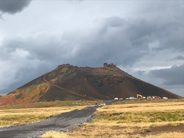
Kerið Crater
From the Secret Lagoon, drive back on Road 359 until you get to Road 35 again and turn left. Continue for about 25 minutes until you see Kerið on the left side. There is a parking lot right next to the crater. But if you are not with a tour, you’ll have to pay a small charge to get to the crater for the local landowners to upkeep the lot, etc. The crater is about 3000 years old and now is filled with a relatively shallow amount of water (22-45 feet deep). To get back to Reykjavik, continue on Road 35 until you get to the ring road (Highway 1). Turn right and follow the signs to Reykjavik.
Day Trips from Reykjavik – Northwest Coast
As day trips from Reykjavik go, the northwest coast trip was one of the most picturesque drives I have ever taken. It was a lovely countryside drive and hardly anybody was on the road. I took highway 1 until Road 54.
Mount Kirkjufell
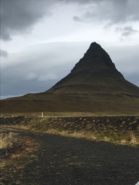
Mount Kirkjufell 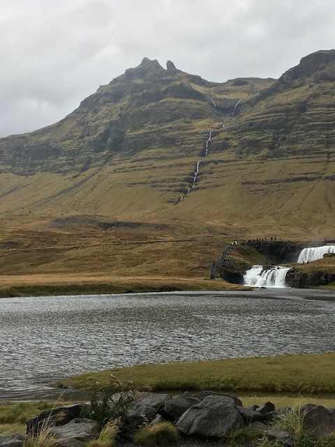
Grundarfjorour Falls
I was trying to make my way up to Grundarfjorour where I had seen Mount Kirkjufell in a stunning photo, as well as in Game of Thrones. Almost 3 hours later, I arrived to get find Mount Kirkjufell to be a pretty small mountain in comparison to beautiful mountain scenery I had gone through to get there. It was hardly recognizable as the Mount Kirkjufell picture I had seen because the picture showed a waterfall almost beside it. However, the photo had to have been taken looking from the small falls on the left side of the road toward the mountain on the right side of the road.
I laughed to myself because the photographer really made the place look like a huge attraction. Don’t get me wrong, the falls were nice but the waterfalls on the south coast are much more dramatic. The parking lot is very small and there is not much hiking there; just up to the falls to get the iconic picture toward Mount Kirkjufell. I followed the whole western coastline into the Snæfellsjökull National Park.
Snæfellsjökull National Park
Snæfellsjökull National Park is out on the Snæfellsness peninsula. I first drove to the Saxhóll volcano crater, where you can park and climb to the top. From the top, you can see to the Atlantic Ocean and the lava fields all around. As I drove through the park, I could see famous Snaefellsjokull volcano, where the Snæfellsjökull glacier lies on top. Scientist say the glacier will probably not exist after the next 50 years due to global warming.

The Snæfellsjökull mountain in the center of the park became famous after Jules Verne described it in “A Journey to the Center of the Earth.” Further along the road on the left, the entrance to the Vatnshellir Cave can be seen. It was raining so hard by the time I was there and did not know about before, so I had not signed up for the guided tour in advance. But you can check it out on Viator and schedule the guided tour if you are heading to the park.
Also, the two Lóndrangar basalt rock pinnacles are not far on the right. I wanted to see some Puffin while in Iceland and this would have been one of the best places since they nest in the hills of the higher cliffs. But it was so misty from the rain that I missed the little birds.
Bjarnarfoss
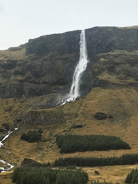
I loved this two-tiered waterfall because of its dramatic 260 feet drop. But the other I liked was its unusual name, which means Bear Falls. It is an odd name because there are no bears native to Iceland.
Conclusion – Day Trips from Reykjavik
I had only 3 days to spend in Iceland, but I am so glad that I had the chance to see this lovely country. The beautifully green countryside reminded me of Ireland with all the grazing sheep. The waterfalls reminded me of the Oregon. The glaciers reminded me of St. Mary’s Glacier in the mountains close to my home in Colorado. The geyser smelled like Yellowstone’s Old Faithful area. All the volcanoes and lava fields reminded me of the Big Island of Hawai’i. It seems like it is the only country I’ve been to lately that offered so many different things to see on such a small island. Even if it’s a quick stop-over, put it on your bucket list to visit Iceland!


I was extremely pleased to discover this page. I want to to thank you for ones time due to this wonderful read!! I definitely appreciated every part of it and I have you bookmarked to look at new information on your web site.
I must thank you for the efforts youve put in penning this site. I am hoping to check out the same high-grade blog posts by you in the future as well. In fact, your creative writing abilities has motivated me to get my very own blog now 😉